Like many people, I’ve experienced fast, efficient, clean, safe and pleasant public transportation in Europe and Asia. Back home in suburban Atlanta it’s different. There are no bus routes that would take me to the north most (closest) MARTA station if I wanted to “Be Smarta, Take MARTA”. The 3, yes, just three, bus routes in my town don’t come near me. I need to drive 30 minutes first if I want to go in to Atlanta on public transportation.
At my last home in Cobb County the closest bus was 2 miles. That sounds so close by comparison, but the reality was even less satisfactory. Cobb Transit was/is separate. The transfer station isn’t close and it takes longer. The trip downtown was a three hour venture (if you drive, not walk to the bus). Who has 6 hours to devote to a daily commute? Even with notorious Atlanta gridlock, only people who have no other choice would do that.
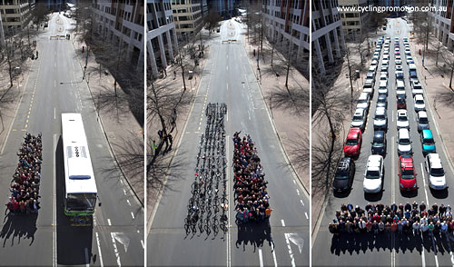
Routes were and are limited in each of the places I lived OTP (Outside the Perimeter) because of low ridership, and ridership is low, at least in part, because of limited (or unavailable) routes. I wanted, and still want, the freedom to pay attention to anything other than traffic while using efficient public transportation with great ventilation and a smaller carbon footprint. Some people define freedom as being the driver. “That’s fine” I would say to them. “But, if I am using public transportation, I’m not on the road competing with you for space in traffic. Supporting public transportation for all of the people like me, makes your life better too.” Maybe I’d have reached them better if I’d had some photos like these below handy. I could put them next to some of constant road construction. I’d like to see those DOT dollars building infrastructure for tomorrow, not gobbling land paving it.
So, why is this in the middle of my KarenGoes.com push toward the cycling video project? Well, because it’s important, there’s a cycling component and, because everything’s connected. Not to mention, the need to repair and update our infrastructure makes the news every day. I have a vision to share, something to build, or build on.
The pandemic complicated already challenged US commitment to high speed public transportation, really, to public transportation at any speed. But, demand is building and things will change. We’ve learned some things and, there are enough ideas being implemented for me to link to existing projects and research for everything I want to talk about incorporating in my vision. It’s time to win the next era, and making public transportation desirable, efficient and highly effective while giving it a sense of place is a significant piece of that.
If You Build It
These are the things I would put together to design a multi-use, multi-level public transportation system centered around a high speed public transportation core. This system will increase options, improve public transportation and reduce traffic on roads. It will fit in existing landuse, reduce heat island effects, hide currently visible utilities infrastructure with increased safety, provide public and ecosystem services, help stabilize the natural environment, reduce and in some places reverse habitat loss, remediate significant factors driving climate change, beautify public spaces, promote public health and greatly amplify public transportation utility while making it all more inviting. That’s a lot, Here goes!
For Starters
Begin in an area with medium to high density residential population (so there will be abundant local potential users). Build a multi-use transportation corridor in, under and above the median of a road or highway.
First, dig the median out to make a utility tunnel. Put in all feasible public utilities and transportation facility utilities. The tunnel will contain things like fiber infrastructure (phone and other telecom). Put in any systems needed to manage and run the transportation system. Put as many ugly power lines that fall on people during earthquakes or wind and ice storms in the utility tunnel, no more digging up underground utilities for maintenance, go to the access tunnel. There can be additional areas underground for auto parking (with charging stations), bike parking, delivery lockers, maybe even auto services like tire stores. This will improve viewscapes and viewsheds while also improving ease of access for maintenance and major repairs
As utilities move into underground spaces, easements on the roadside will become available for moving lanes out or creating green space. Power companies and the DOT have entire departments to work out the easements for changes in roads and lines. I worked in a power company department once doing exactly that. As the high speed transportation lines move out to areas with less population density, the number of things that are practical to put underground will decrease. Dirt from the tunnel can be used to build up other areas I’m about to talk about.
Ground Level
The first or ground level (level with the road) will be open with mixed-use, including some street level car parking. A few businesses can be incorporated in the support structure (those providing the goods and services you see in train and metro stations worldwide for convenience and transportation services, perhaps including bicycle storage, bicycle rentals, locker storage and delivery or parcel lockers). And, being ground, or street level, it may also include turn lanes and cross streets as needed for people using the original roadway.
First Transportation Level
The next level above ground will become the first transportation level with high speed public transportation, such as high speed rail. Why high speed rail? Travelers in Tokyo (the largest city in the world) can make a trip in a small fraction of the time it takes to make a similar trip in a city like Atlanta where the population is much, much less dense. A public transportation user can occupy themselves in any self contained activity instead of being frustrated by drivers, and (if it’s high or even medium speed rail) get there sooner, safer, at lower cost and with less negative environmental impact.
Like many systems around the world, the high speed level will also have parallel local transportation lines with more frequent stops. Where there isn’t enough space to build a local traffic line parallel, those lines will move to the level above. Waiting areas and seating compartments will be well ventilated with air circulation, filtration and cleaning systems that reduce modern (as well as ancient) health risks. I see this high speed/local speed architecture as incorporating all of the smartest and newest technology, but I don’t see it being visibly very different than the best modern transportation systems that already exist.
Other Commuter Corridors
The second level above ground (or the level above powered commuter lines) will be commuter bike path. Where this level is sandwiched in the transportation column the commuter bike space will have sides that let in light and air for physical and mental health. The support structure will have public art. It will have bike parking or storage and rentals, unmanned bike repair stations for self repair, sales or vending machines for drinks, snacks and bicycle repair items like tubes or other wear parts and equipment.
The bike path can have loops or elevated access trails directly connected to existing systems so that, in some places, this level can be accessed without going through the other levels, transforming commuter and pleasure cycling to a viable option for more people. There could be kiosk coffee shops with balcony seating near an overlook or park, perhaps with a green roof.
The Winding Path
The level beside or above the bike paths will be for walkers, skaters, families with young unpredictable children, handicap scooters. It will be for the people who want to move along on their own power, but for whatever reason, won’t move as quickly, or as predictably as a commuter cyclist. Half of this corridor could be dedicated to hover boards, skaters and other users that don’t mix well with pedestrian traffic or commuter cyclists. Where there is room, there could be skate/bike park side features where bikes, boards and skaters could detour from time to time for acrobatic recreation and distractions. This can come out into an adjacent built up area maybe in an extension like a rink area and could be designed as public art to provide visual interest to non-users as well as users. These areas will be connected to the public use areas of the complex.
Up on the Roof
The roof of the transportation column will have components that include the features of a green roof, a linear park and wildlife bridges with additional features that local communities ask for. It might include children’s sports fields or complexes, water features, public art, native trees and plants, some edible plants, possibly community vegetable gardens, space for public meetings, green space for group or individual exercise or meditation, outdoor exercise equipment, story teller’s square, entertainment, etc. This is the space that is used like a local public park, incorporating the destinations that many people seek into the transportation column itself, making it a space undoes much of the damage that transportation causes now and increases available land for public use. It will reduce heat island effects and remediates stormwater management problems.
In locations important because of adjacent habitat or parks, the linear park on the top level will connect to adjacent land to become a habitat greenway or wildlife bridge where animals can move across the transportation column from habitat on one side to habitat on the other reducing road kill and other negative effects of fragmentation. The earth for this can be partially sourced with the material dug out for the underground utility corridor.
Throughout the system I see a lot of structural, functional, system, environmental and social integration similar to the way this park was designed, almost as though it were a living organism. The more natural systems that can be used to provide services the better. Note that they use a lake for irrigation and even have gardens in the underground parking structure!
In areas where hard surfaces are required, pervious pavements will add to resilience in dealing with stormwater management.
Solar and or wind power generators will be incorporated into the structure where appropriate. Solar may be in multiple forms, perhaps in windows, in canopies, perhaps in horizontal structures that will shade the original street and auto traffic below.
There will be low maintenance green or living walls with local native plants where appropriate providing shade and other cooling as well as ecosystem services and landscaped beauty. If this is what you think of when you hear “living wall”, there should be places for that too.
Any level other than the green roof might have delivery service lockers, coffee kiosks, vending, small unique restaurants and chains, financial services, convenience businesses, emergency services, etc…
Existing power easements become available for expansion if needed to replace lanes of traffic, as connecting greenway, or as low maintenance landscaped areas with plants chosen to provide native habitat that will reduce stormwater management burdens and reduce flooding.
Moving up and putting this in existing transportation corridors, will preserve the opportunity for land that would otherwise be gobbled up in new roads to remain available for higher and better use. At the same time, filling and covering the transportation center with living green roofs and linear parks takes land that would otherwise contribute to heat island effects and turns it into temperature mediating spaces that provide multi-use public space as well as transportation.
Incorporating solar and wind power generation features will improve efficiency and reduce costs while saving even more land for other uses.
Covering this transportation system with native plants and green spaces where possible will improve appearance, reduce the effects of Urban Heat Island, improve stormwater management, reduce flood risk, reduce climate change effects, and be inviting.The green roof with linear parks and public use areas will draw people in to local and community use of the facility, provide hard to find space for all kinds of parks, and so much more.
At the end of the line, before a transportation car turns to go the other way, it will move into an enclosed area that will quickly disinfect with UVC light, or other appropriate technology.
As the line moves out to less densely populated areas, the speed will increase, the stops, services and amenities will spread out and the wildlife bridges will become more frequent as they begin to look more like green overpasses.
I can see dollar signs in the eyes of many readers. The money is going to get spent. It’s just a matter of how. I look at this Billion dollar project and see the 100 year flood zones being redrawn a few times. We can spend it better, to serve more people better with fewer expensive side effects and more services. The ideas I’ve shared, and more are out there. People are making them work. We can make them work. If we combine them in a powerful way like this, the rewards will be powerful.